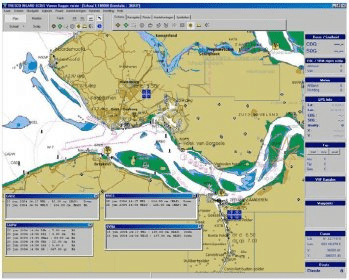
The Tresco Inland ECDIS viewer is the standard software for navigation in Inland Shipping. The program is connected with a GPS system and shows continiously the ships position on screen. Everything you need for navigation is on the map. This is information like VHF channels, radar information, radio reporting points, place names, distance marks, bridge clearance, harbour numbers, pictures of bridges etc… In a separate window the standard VHF channels, river kilometer and panels are shown. When placed in the neighberhood of the radar the Tresco Inland ECDIS viewer helps in distinguishing between ships and buoys. Navigation in ‘North Up’, ‘Course Up’ and ‘Radar’ mode is possible.
Comments